
Description
On April 30, 2010, in accordance with the resolution of the Government of the Republic of Kazakhstan No. 370, the “Dzungarian Alatau state National Natural Park” was established, consisting of branches of Sarkan, Alakol, Lepsy.
The total area of the park is 356022 hectares. Administratively, the park covers Aksu, Sarkan and Alakol districts of Almaty region. 55257 hectares in Aksu district, 151947 hectares in Sarkan district, 148818 hectares in Alakol district.
The Dzungarian Alatau is a mountain in the eastern part of Kazakhstan, a northern and northwestern extension of the Dzungarian Mountain system. It stretches in a latitudinal direction between the Alakolkazan riverbed in the North and the Ili riverbed in the South. Length 450 km, width 100-200 km. The Dzungarian Alatau is crossed by the Koksu River in the West and the Buratal River in the East. These two parts form two large mountain ranges called the northern and Southern Dzungarian Alatau.
Nature of the terrain
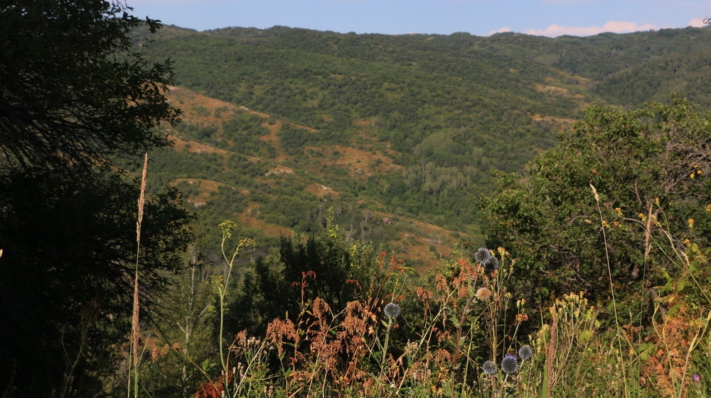
Near the border with Kazakhstan, Urkhashar, which is located on the territory of China, passes to the Barlyk Mountains (3300 m, the so-called Zhair and fat mountains). Between these mountain ranges is a wide valley depression. In the mountain valleys there are many small stone mounds (Burrows). The stream connects Lake Ebinur with the Alakol kazanshuk, which is a natural pass called the Dzungarian gate. The Kazakh part of the Dzungarian Alatau begins west of the Dzungarian gate. In this part, the Dzungarian Alatau turns into a giant mountain range with an asymmetric structure. The Dzungarian Alatau consists of two main ridges (North and South), separated by the Koksu River. The highest point of the northern ridge is Besbakan (4622 m). The northern mountain range gradually turns into a wide plain, forming a staircase-like Alasar to the Northeast. At its upper stage are Tastau, Akanjailau, Kotyrtas, Mynshukur (2800-3000 m). Among them are small inter-mountain pits. The second stage is the Kungei, Eshkiolmes, Suyktau, Karachoky, Zheldikaragay (2000 m) mountain ranges. The third stage is the Shybyndy, Karasaryk, Kyrykkol pre-mountain valleys (1500-1600 m), from which the Tekeli and Saikan mountains (1100 m) are located to the north-east. The highest point of the Southern Ridge is Muztau (4370m). The relief of the southern mountain range is also stepped, but more strongly fragmented compared to the northern ridge. In the West and south-west of it are the pre-mountain ranges Itshoky, Kotyrkain, Altynemel, and Suatau. They are approaching the valley of the Ili River. The terrain of the northern slope is flat, sloping, and the mountain hills are flat. The slopes of the valleys separating the mountain ranges are steep, jagged. The southern slopes are zhalavtava. The mountain peaks are not flat compared to the north, but elevated.
Geological rocks
Their mountain ranges are formed by pre-Cambrian granites and crystalline granite shales. In the northern and northwestern parts of the Dzungarian Alatau, in addition to the main rocks consisting of Silurian and Devonian sandstones, clay shales, sedimentary rocks of the lower and middle Paleozoic are also found. In the southern and southwestern parts of the mountain system, many upper Paleozoic rocks are distributed. They consist of sandstone, shale, limestone and conglomerates of the coal and Permian eras. Sedimentary rocks of the Paleogene and Neogene are found in inter-mountain pits and valleys, at the foot of the mountain. The Dzungarian Alatau was transformed into a folded mountain during the Caledonian and herzin mountain formations, and in the Mesozoic and lower Cenozoic, it was destroyed and gradually leveled under the influence of external forces. As a result of the intensive Alpine fold, it later turned into a high mountain with a steep slope. The formation of the relief was facilitated by both ancient and modern ice caps. Traces of glaciation are observed in different places.
Mineral resources
There are polymetallic deposits. The ore contains rare metals such as cadmium, indium, bismuth, selenium, and Mercury. There are small deposits of quartz gold on the territory. Coal reserves were found in the inter-mountain recesses.
Climate
Dzungarian Alatau is located far from the World Ocean. Its climate is influenced by the cold air of the Arctic, the hot air of the Turan lowland and the Siberian anticyclone. The foothills of semi-deserts and deserts are characterized by a continental climate. On the slopes of the high mountains, the climate is temperate: winter is cold, summer is temperate. The average temperature in January is between -10°-11°C, in July +18°+20°C. heavy precipitation falls on the mountain slopes. The average annual precipitation is 600-800 mm, in the Southeast 400 mm. In winter, there is a lot of snow, and the mountain ranges are covered with glaciers. A strong wind blows through the Dzungarian gate. It is formed by the collision of a cyclone coming from the Barlyktau and Mailytau ranges in the Dzungarian Alatau and an anticyclone passing through the south-east of the Dzungarian gate. The wind is warm, its speed is 60-80 M / s. most often it blows 1-2, sometimes even 3-7 days. Through this gate also passes the cold saikan wind blowing from the Saikan mountains.
Rivers and lakes
The Dzungarian Alatau has extensive water reserves. The rivers here flow into the local lakes. In the north, the Irgayty river flows into Zhalanashkol, the Zhamanthi river flows into Alakol, and the naughty Sasykkol river flows into Zhalanashkol. Most mountain rivers (Lepsy, Karatal, Sarkan, Buyen, Aksu) flow into Lake Balkhash. The Southern Ridge has significant water reserves. The Khorgos River, which flows along the Chinese border, flows into the Ili River. In the north of ILI flows the Usek River. The burakozhyr River is also directed to Ili, but it dries up due to the fact that it is very hot and does not have enough water. The Karatal river flows between the northern and Southern Ridges of the Dzungarian Alatau. It flows into Balkhash along with the Rivers Koksu, Bije (along with its tributaries Makanchi, Karabulak, Sarybulak, Kusak). In the mountains there are glaciers, from which the largest rivers of the Dzungarian Alatau originate. Most of them start from the northern ridges. There are 1369 glaciers with a total area of 1000 km2. The largest glaciers are located in the upper reaches of the Lepsy River. The glaciers of the Dzungarian Alatau are divided into seven groups: Yrgayty, Tentek, Lepsy, Baskan, Sarkan, Aksu, and Buyen.
Flora and fauna
The Dzungarian Alatau is a kind of bridge between the mountains of Siberia and Central Asia. In the north, the Siberian Meadow-steppe zone is distributed, in the South-steppe landscapes. The high-altitude zones of the mountain begin with the semi-desert zone, covering the range from 500-600 m to 1200-1400 m on the pre-and intra-mountain plains. Irrigated arable land and pastures are located here. Vegetables, fruit trees, forage grasses and grain crops are grown. The steppe zone (from 1200-1400 m to 1800-2000 M) is located at high altitude. Spruce forests and cedar trees grow here. It is home to marals, bears, and roe deer. Meadows are suitable for grazing livestock. The high belt of the mountain lies at an altitude of 2200— 2400 m in the North and 2400-2500 m in the South. There are subalpine meadows, snow and glaciers. Some parts of the high mountain are used by pastoralists as pastures. There are many Altai and Tien Shan species in the animal world.